Legends say that, unlike the tables in the imperial navigation guides, the massive clockwork Orrery's the Empire maintained at their Havens could approximately calculate travel times directly from the Waking World without the need for measurements taken inside the Shadowlands. The secret of constructing these devices is long lost, however.
The sailors of the Annwyn Empire were consummate navigators and mathematicians, the best the world has ever known. They were also highly organized, mapping and charting much of the world. To support these efforts, they devised a coordinate system that allowed them to identify any point on the world's surface precisely with only three coordinates.
Latitude: The angular distance north and south of the equator
Longitude: The angular distance east or west of the Prime Meridian, which ran directly through the Emperor's throne in the Annish capital city of Findias.
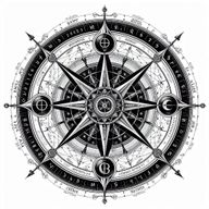
Juxtaposition: The strangest of these coordinates, sometimes called Juxtaposition of Shadow, had a number of special properties. Unlike the other two coordinates, it was not constant in time but varied wildly depending on the season, astrological conditions, and even the time of day. In the Waking World at least, It only varied from zero to 180 (unlike Lat and Long that rang from -180 to +180). It was only used for two very particular esoteric purposes: calculating the time and place of a "conjunction," a spot on the surface of the sea where the juxtaposition is zero and thus a ship could sail into The Shadowlands , and calculating the heading and amount of time to travel between such conjunctions while in the Shadow.
Conjunctions:
Calculating conjunctions depends on a number of celestial measurements, measurements that must be taken both in the Waking World and in The Shadowlands. While it is possible to calculate multiple conjunctions while in the Waking World and assume a route between them must exist in the Shadowlands, two conjunctions that are only a few miles apart in the Waking World may represent a voyage of a thousand years in the Shadowlands. Similarly, two conjunctions ten thousand miles apart in the Waking World may only represent an hour's voyage in the Shadow. It is impossible to calculate the duration of this route by using the tables provided in this book. Celestial measurements must be taken in the Shadowlands itself.
Such measurements are extremely difficult since the stars of that world are fixed and do not move. However, the book speaks of proximity to various constellations, that constellations can appear subtly nearer or farther away if very careful measurements of the angles between the stars of a particular constellations are made.